")
")
 — 2026 Guide")
 — 2026 Guide")
 — 2026 Guide")
Storm Damage Restoration Experts | Serving IL, WI, IN
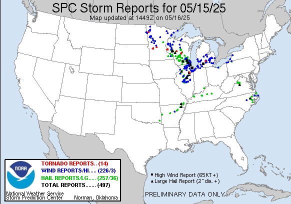
Overnight and into the early morning hours of May 15, 2025, a severe weather outbreak swept through the Midwest, leaving a massive trail of destruction.
The storm system impacted over 3 million homes across Illinois, Wisconsin, Michigan, and Minnesota, unleashing:
- Hail up to 3.5 inches in diameter
- Straight-line winds topping 90 MPH
- Confirmed tornado touchdowns in multiple counties
At Allied Emergency Services, we are already responding to emergency calls in Cook, Lake, DuPage, Kane, McHenry, Will, and Kendall Counties in Illinois, and expanding operations across Wisconsin and Indiana to meet the demand.
Storm Impact at a Glance:
Summary of Most Extreme Impact Zones:
- Largest Hail: Eau Claire County, WI – 4.00″ hail recorded in Altoona caused severe vehicle and roof damage
- Strongest Wind Gusts: Grundy County & Chicago, IL – 79 MPH gusts recorded near Gardner and Navy Pier
- Most Tornado Reports: Portage & St. Croix Counties, WI and Swift County, MN – confirmed touchdowns with debris and damage documented
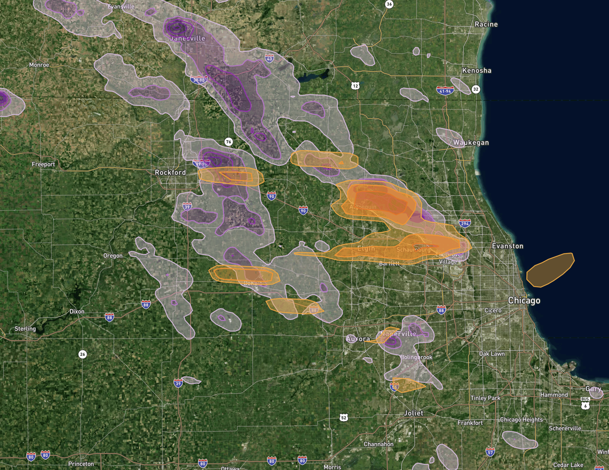
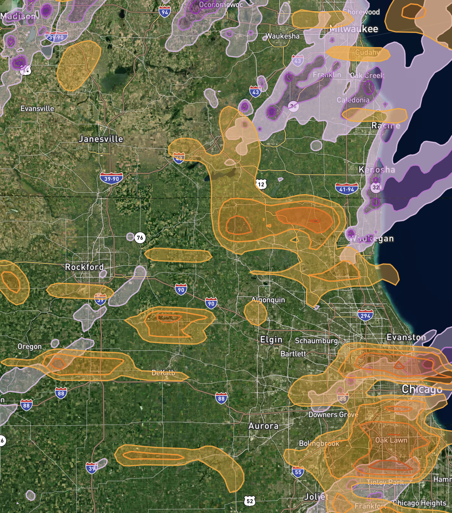
Hail Swath: 1,137,842 Homes Affected
- Chicago Metro Area: 403,572 homes impacted
- Milwaukee, WI: 302,603 homes impacted
- Madison, WI: 100,069 homes impacted
⚠️ Largest hailstones recorded at 3.5 inches (tennis ball to baseball-sized) caused extensive damage to roofing, siding, windows, and gutters.
Wind Swath: 2,063,843 Homes Affected
- Chicago Metro Area: 1,108,409 homes
- Grand Rapids, MI: 204,627 homes
- Kalamazoo, MI: 204,139 homes
Wind gusts up to 90 MPH uprooted trees, snapped power lines, and tore off shingles and exterior cladding. Some reports confirm semi-truck rollovers and structural collapses.
Tornado Confirmations
Touchdowns were reported in:
- Swift County, MN
- St. Croix & Clark Counties, WI
- Grundy County, IL
- Eaton County, MI
🌀 Reports include debris fields, overturned vehicles, and funnel clouds photographed on the ground.
Tornado Report Summary:
Time	Location	County	State	Lat	Lon	Comments
1816	2 E Danvers	Swift	MN	45.28	-95.72	Location estimated based on spotter report. Time is approximate. Photo provided. (MPX)
1838	1 W Benson	Swift	MN	45.32	-95.62	Debris visible. (MPX)
1947	2 ENE Spring Hill	Stearns	MN	45.53	-94.80	Debris reported (trees). (MPX)
2030	3 N Roberts	St. Croix	WI	45.02	-92.54	Deputy reported a tornado on the ground north of Roberts along 110th. (MPX)
2034	7 S Deer Park	St. Croix	WI	45.09	-92.39	Sent photo of ongoing tornado. (MPX)
2204	4 SSW Loyal	Clark	WI	44.69	-90.52	Law enforcement reported a tornado on the ground near Loyal ... WI. (ARX)
2209	4 NE Crookston	Polk	MN	47.82	-96.54	Deputy report of tornado east of Crookston. Radar estimated. (FGF)
2257	2 WSW Bancroft	Portage	WI	44.30	-89.55	Brief tornado report via Law Enforcement. (GRB)
2301	2 N Keene	Portage	WI	44.39	-89.45	Observed funnel cloud near County Hwy J. (GRB)
0046	Braceville	Grundy	IL	41.22	-88.26	Damage to tree branches and siding. Radar estimated. (LOT)
0336	3 SSW Waverly	Eaton	MI	42.70	-84.65	Semi overturned on highway. Radar confirmed debris. (GRR)

Wind Damage Report Summary:
Time	Speed (MPH)	Location	County	State	Lat	Lon	Comments
0044	79	1 N Gardner	Grundy	IL	41.21	-88.31	Multiple wind gusts in excess of 75 mph with a peak gust of 78.7 mph. (LOT)
0124	79	3 NE Navy Pier	Cook	IL	41.92	-87.57	Harrison Dever Crib reported 79 mph gust. (LOT)
0101	74	2 W Bonfield	Kankakee	IL	41.15	-88.09	Home weather station peak gust of 73.6 mph. (LOT)
2359	69	3 NNE Leland	DeKalb	IL	41.66	-88.78	Private station reported 69 mph gust. (LOT)
2340	67	2 ENE Genoa	DeKalb	IL	42.11	-88.65	Measured 67 mph gust east of Genoa. (LOT)
0003	60	2 W North Bay	Racine	WI	42.76	-87.81	Racine Airport reading. (MKX)
2354	UNK	Wauwatosa	Milwaukee	WI	43.06	-88.03	Multiple calls for wires down and some tree damage. (MKX)
2336	UNK	1 W DeKalb	DeKalb	IL	41.93	-88.77	Several photos relayed of tree damage. (LOT)
0002	UNK	1 E Spring Grove	McHenry	IL	42.44	-88.22	Tree uprooted. Fence damaged. (LOT)
Full Hail Report Summary:
Below is the list of all confirmed Illinois and Wisconsin hail reports from the May 15, 2025 storm outbreak. Each entry includes time, hail size (in inches), location, and damage notes.
Time	Size (in)	Location	County	State	Lat	Lon	Comments
0041	3.00	3 N Saunemin	Livingston	IL	40.93	-88.42	3-inch hail confirmed. (LOT)
0044	2.75	1 SE Emington	Livingston	IL	40.96	-88.35	Baseball size hail verified via social media. (LOT)
0045	2.50	Fairbury	Livingston	IL	40.75	-88.52	Significant hail damage. (LOT)
0046	1.75	Dwight	Livingston	IL	40.88	-88.43	Golf ball size hail. (LOT)
0048	1.50	Morris	Grundy	IL	41.37	-88.43	Ping pong ball size hail. (LOT)
0050	1.25	Plainfield	Will	IL	41.62	-88.20	Half dollar hail with minor damage. (LOT)
0100	1.00	Wheaton	DuPage	IL	41.86	-88.11	Quarter size hail. (LOT)
2342	2.00	Gurnee	Lake	IL	42.38	-87.94	2 inch hail confirmed by spotter. (LOT)
2313	2.50	4 W Waterford	Racine	WI	42.77	-88.28	Tennis-baseball sized hail. Vehicle damage. (MKX)
2115	4.00	2 W Altoona	Eau Claire	WI	44.81	-91.47	Largest hail of the outbreak. (MPX)
2108	2.00	Madison	Dane	WI	43.08	-89.39	Hen egg size hail. (MKX)
2155	1.75	1 NW Wisconsin Dells	Sauk	WI	43.64	-89.79	Golf ball size hail. (MKX)
2102	1.75	6 E Plain	Sauk	WI	43.28	-89.93	Large hailstone next to a hen egg. (MKX)
2118	2.75	3 SSW Altoona	Eau Claire	WI	44.77	-91.46	Baseball size hail confirmed. (MPX)
2108	1.75	3 W Alma Center	Jackson	WI	44.44	-90.97	Golf ball size hail. (ARX)
2237	1.50	4 SW Beaver Dam	Dodge	WI	43.41	-88.87	Ping pong ball hail. (MKX)
2350	1.50	2 WSW Amherst Junction	Portage	WI	44.46	-89.35	Ping pong ball size hail. (GRB)
2354	2.00	Winthrop Harbor	Lake	IL	42.48	-87.83	Multiple public reports. (LOT)
📊 Hail Damage Analysis by State:
A snapshot of damage severity and frequency by state.
| State | Report Count | Average Size (in) | Max Size (in) |
|---|---|---|---|
| WI | 149 | 1.41 | 4.00 |
| IL | 61 | 1.46 | 3.00 |
| NC | 13 | 1.62 | 2.50 |
| KY | 12 | 1.33 | 1.75 |
| AR | 10 | 1.28 | 1.75 |
| VA | 9 | 1.42 | 2.00 |
| MN | 7 | 1.14 | 1.50 |
| MO | 5 | 1.60 | 2.00 |
| IN | 2 | 1.00 | 1.00 |
| OK | 1 | 1.25 | 1.25 |
For a detailed PDF or full spreadsheet, contact our office.
What Homeowners Need to Do Now:
- Document Damage Immediately – Photos, videos, and timestamps help your insurance claim.
- Secure Your Property – We offer same-day tarping, boarding, and emergency services.
- Avoid DIY Roof Work – Dangerous, especially after hail/wind events.
- Contact Allied Emergency Services – We help you with your insurance repairs to ensure you’re fully restored.
Emergency Storm Response – Call Now
Allied Emergency Services is standing by 24/7 to provide:
- Free storm damage inspections
- Insurance Repairs consultation
- Code-compliant roof, siding, and window replacement
- Licensed, bonded, and insured restoration
📞 CALL 1-800-792-0212
📍 Serving Illinois, Wisconsin, and Indiana
🌐 www.alliedemergencyservices.com
Why Choose Allied?
We’re not just contractors — we’re insurance restoration specialists who specialize in restoring your loss to pre-loss condition.
When insurers lowball your claim, we bring building codes, manufacturer specifications, and legal expertise to the table.
One call does it all — from inspection to full rebuild.
Don’t wait until your damage gets worse.
Let Allied Emergency Services help you recover fast, fair, and fully.
If your home is located in any of the listed storm-affected zones, you may be eligible for full roof and siding replacement at no cost beyond your deductible.
🧰 Contact Us Immediately to Schedule Your Free Inspection:
📍 Allied Emergency Services, INC
📞 1-800-792-0212
🌐 www.alliedemergencyservices.com
📧 info@alliedemergencyservices.com