⚡ Storm or Roof Damage? Get a FREE Estimate
Text ESTIMATE to (844) 907-2546
Or call (800) 792-0212 for 24/7 emergency response
AI-powered • No obligation • Licensed IL & WI
Nature has an uncanny ability to leave us awe-inspired and humbled, reminding us of its immense power. On June 25, 2023, our region experienced a hailstorm of unprecedented intensity, leaving a trail of destruction in its wake. In this comprehensive blog post, we will delve into the facts, reports, and events surrounding the storm, including hail damage, hailstone size, tornadoes, and the profound impact it had on the affected communities.
The Lead-Up to the Storm
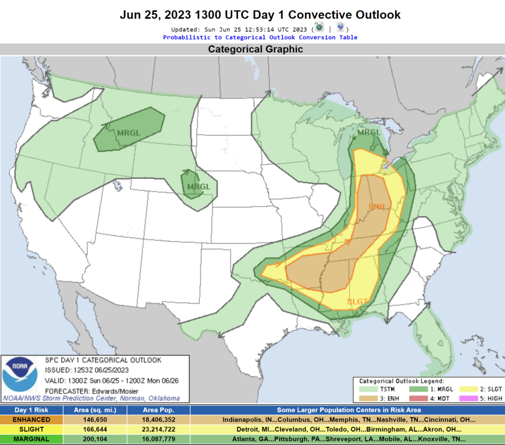
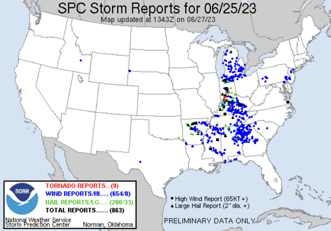
In the days leading up to June 25, 2023, weather forecasts indicated the possibility of severe thunderstorms in our region. The Storm Prediction Center (SPC) had issued an enhanced risk for severe weather, including the potential for large hail, damaging winds, and even isolated tornadoes. As the day unfolded, the atmosphere became increasingly unstable, with rising temperatures and high humidity levels. These conditions set the stage for an explosive thunderstorm formation.
Hailstorm Impact on Residential Areas
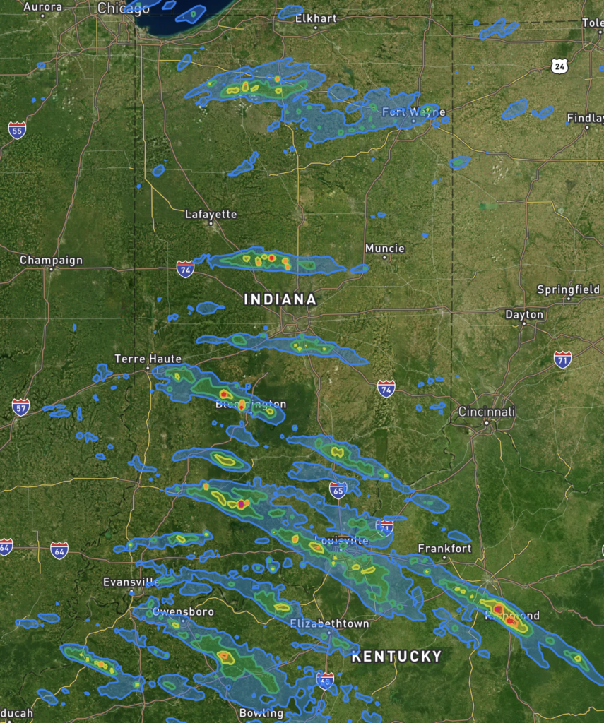
Indianapolis, IN Area: Around 150,595 homes fell within the swath of hail, ranging in size from smaller hailstones up to 2.5 inches in diameter. At approximately 8:15 PM, residents witnessed the formidable force of the storm, highlighting the need for robust protective measures for homes in this area.
Gary, IN Area: Within the hail swath, encompassing the Gary, IN area, approximately 137,807 homes were at risk. The hailstones varied in size, with the largest measuring up to 2.5 inches in diameter. This event occurred at approximately 6:35 PM, leaving homeowners with a stark reminder of the importance of safeguarding their properties.
Evansville, IN Area: In the Evansville, IN area, 84,981 homes were exposed to the impact of severe hailstorms. The hail sizes ranged from smaller stones to 2.5-inch diameter hail. At approximately 10:00 PM, residents in this region experienced the intensity of the storm firsthand, emphasizing the critical need for adequate protection against future weather events.
Tornadoes and Additional Severe Weather
In addition to the hail, the storm system spawned several tornadoes in nearby areas. The SPC had issued tornado watches and warnings as the supercell thunderstorms developed. These tornadoes caused further devastation, destroying homes, uprooting trees, and creating a sense of fear and panic among residents. The combination of tornadoes and the massive hailstones made the storm particularly dangerous and destructive.
Indianapolis, IN Area Tornado Reports:
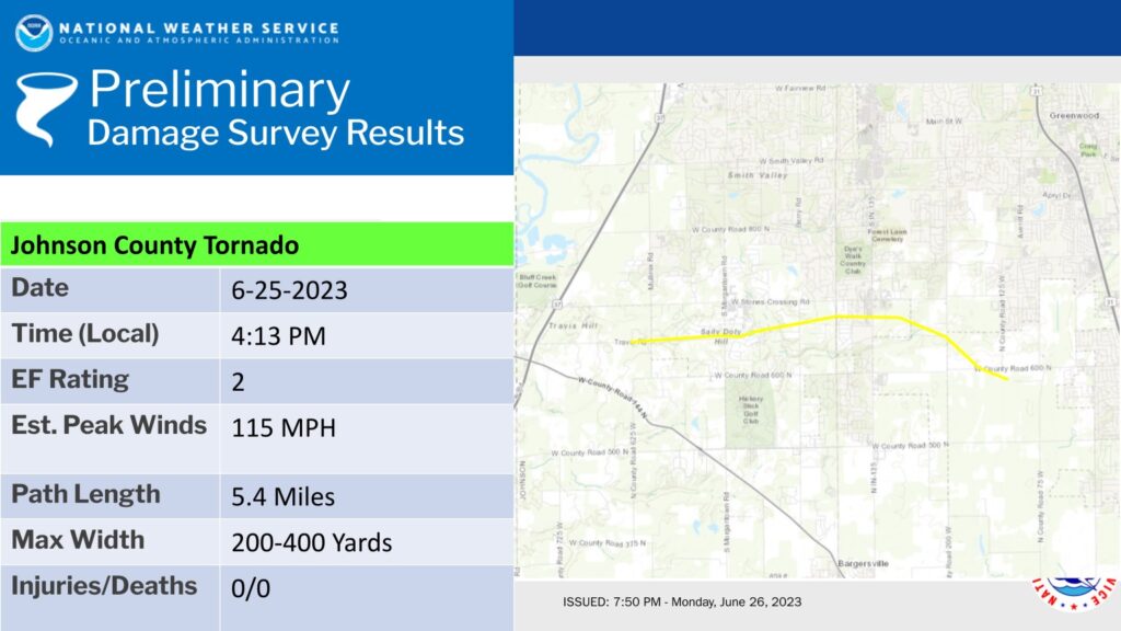
3 ENE Waverly, Johnson, IN: NWS Survey found an EF2 tornado with max wind speed of 115 mph, path length of 5.4 miles, and max width up to 400 yards.
- 2 ENE Waverly, Johnson, IN: Videos on social media of a tornado on the ground at the intersection of I-69 and SR-144.
- 3 WNW New Whiteland, Johnson, IN: Multiple videos on social media of a tornado on the ground near Stones Crossing Road and State Road 135.
- 2 N New Whiteland, Johnson, IN: Multiple pictures from the public of a possible tornado near Highway 31 and Worthsville Road.
Evansville, IN Area Tornado Reports:
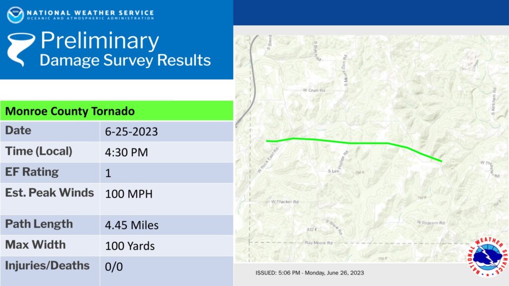
6 SE Solsberry, Monroe, IN: NWS Survey found an EF1 tornado with max wind speed of 100 mph, path length of 4.45 miles, and max width of 100 yards.
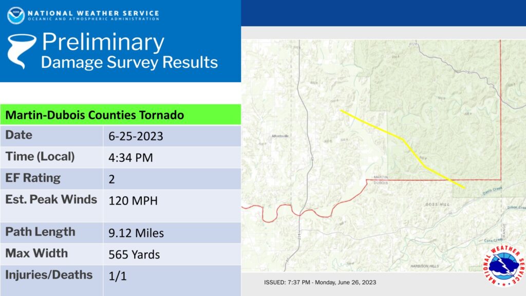
5 ENE Alfordsville, Martin, IN: NWS Survey found an EF2 tornado with max wind speed of 120 mph, path length of 9.12 miles, and max width of 565 yards. 1 fatality and 1 injury reported.
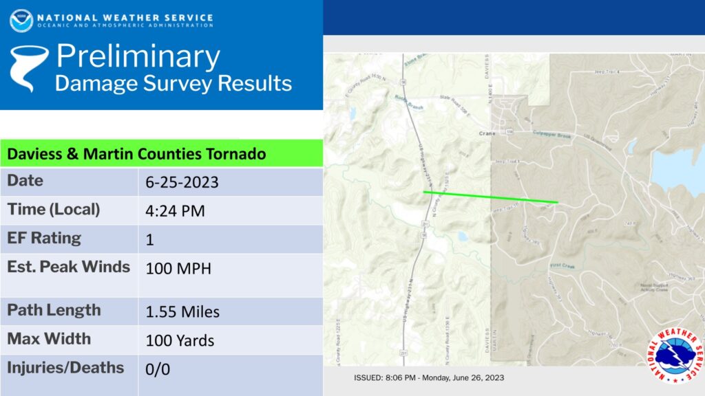
1 SW Crane, Daviess, IN: NWS Survey found an EF1 tornado with max wind speed of 100 mph, path length of 1.55 miles, and max width of 100 yards.
Human and Economic Consequences to Indiana
The hailstorm had significant implications for both individuals and the local economy. Many residents experienced power outages that lasted for several days due to downed power lines and damaged electrical infrastructure. This disruption affected businesses, schools, and the overall quality of life in the affected areas. Insurance claims for property damage will surge, highlighting the immense financial burden imposed on homeowners, businesses, and insurance companies.
Community Response and Recovery Efforts
NWS Indianapolis meteorologists will be conducting damage surveys. Expected locations to be surveyed include:
Johnson County in the Greenwood-Whiteland areas
Martin County area
Southwest Monroe County
Severe storms pose a significant threat to homes and communities, but with the right preparations and assistance from Allied Emergency Services, you can mitigate the risks. Our expert team is dedicated to providing reliable roofing, siding, and window solutions to protect your home from the forces of nature. Stay tuned for more insightful articles and tips on how to ensure your property remains safe and secure. If you or someone you know may have been impacted by storm damage call 1-800-792-0212 now for a FREE no obligation property inspection.
#StormAlert #WeatherUpdate #SevereWeather #StormWatch #HailStorm #TornadoWarning #Thunderstorm #WeatherEvent #StormDamage #StormChasing #WeatherSafety #NaturalDisaster #WeatherForecast #ExtremeWeather #StormPreparation #EmergencyResponse #SevereThunderstorm #WeatherAwareness #WeatherConditions #StaySafe #Indianapolis #Evansville #Greenwood #JohnsonCounty
⚡ Need Storm Damage Help? We Serve 155+ Cities
Allied Emergency Services provides 24/7 emergency restoration across Illinois, Wisconsin, Indiana, and Michigan. Text ESTIMATE to (844) 907-2546 for a free estimate in minutes.
Top service areas: Chicago • Naperville • Aurora • Kankakee • Joliet • Rockford • Schaumburg • Milwaukee • Madison • We’re Hiring!
⚡ Storm or Roof Damage? Get a FREE Estimate
Text ESTIMATE to (844) 907-2546
Or call (800) 792-0212 for 24/7 emergency response
AI-powered • No obligation • Licensed IL & WI
Need hail damage help?
Allied Emergency Services — Licensed IL & WI Hail Damage Specialists
For 27 years, Allied has been restoring hail damage across Illinois and Wisconsin. IICRC-certified, EPA Lead-Safe, IL Licensed Roofing Contractor #104.019029. 24/7 emergency response.
Learn about our Hail Damage service →Free property assessment within 24 hours · No obligation · Insurance claim support