⚡ Storm or Roof Damage? Get a FREE Estimate
Text ESTIMATE to (844) 907-2546
Or call (800) 792-0212 for 24/7 emergency response
AI-powered • No obligation • Licensed IL & WI
In the wake of the severe storms that struck the Chicago metro area on February 27, 2024, Allied Emergency Services, INC stands ready to assist homeowners and businesses affected by the destructive forces of nature. As a full-service restoration contractor specializing in storm damage restoration and emergency services, we are committed to restoring properties and providing peace of mind to our clients during challenging times.
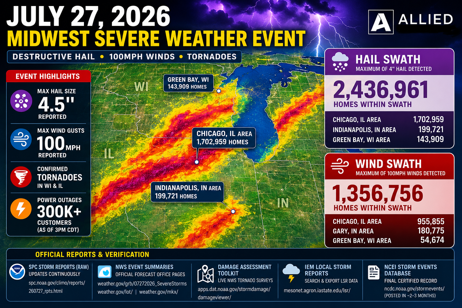
February 27, 2024 Severe Storms in Chicago Metro Area
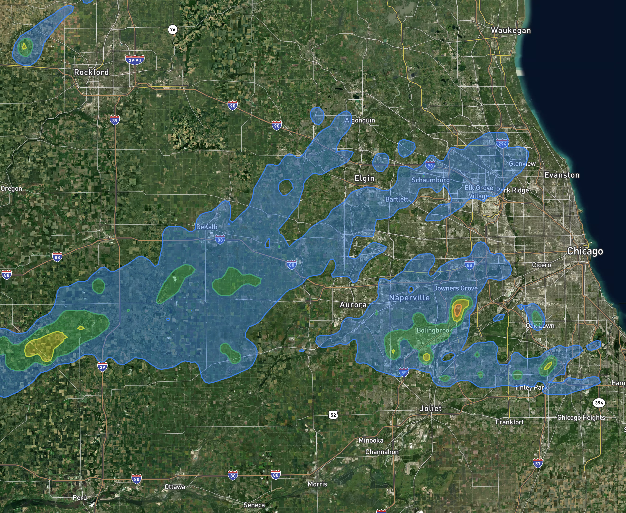
- Severe thunderstorms developed on Tuesday, February 27th, following summer-like, record warmth, impacting northwest Illinois and spreading eastward across the Chicago metro area.
- A total of 11 tornadoes touched down in Illinois, with an additional tornado reported in Indiana, marking the most tornadoes in a February event in the NWS Chicago area since official records began in 1950.
- This event marked only the fourth time on record that tornadoes were observed in the NWS Chicago forecast area in February.
- Large hail, with reported sizes of 2-2.5″ in diameter, was observed in several locations as the storms passed through the area.
- A Tornado Watch was issued at 3:54 PM CST, covering the Quad Cities area, NWS Chicago forecast area, and far southeast Wisconsin. Subsequently, several Tornado Warnings and Severe Thunderstorm Warnings were issued by NWS Chicago to alert impacted areas.
- The severe weather followed record warm temperatures observed on February 26th and 27th. Chicago set two new daily temperature records, while Rockford set three consecutive daily high temperature records, including breaking its all-time warmest temperature record for both February and meteorological winter.
Key Highlights:
- Record Warmth: Rockford set new daily high temperature records on February 26th and 27th, with highs of 73°F and 78°F respectively. These temperatures surpassed previous records and contributed to the warmest February on record for both Chicago and Rockford, making it one of the warmest winters on record for both cities as well.
Tornadoes Strike Northern Illinois and Northwest Indiana
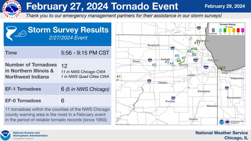
- Annawan, IL Tornado:
- Event summary available from NWS Quad Cities.
- Compton, IL Tornado:
- Brief touchdown northeast of Compton.
- Caused roof damage to a farm outbuilding.
- Waterman, IL Tornado:
- Touched down briefly in an open field.
- Minor damage to a farmstead before lifting.
- Hinckley to Big Rock, IL Tornado:
- Documented by storm chasers.
- Damaged farm outbuildings, peeled shingles off roofs, caused tree damage.
- Lifted near Big Rock.
- Elburn/Campton Hills, IL Tornado:
- Touched down just north of Route 38 and Meredith Road.
- Tracked northeast into Campton Hills, causing mainly tree damage.
- Some damage to a grain elevator and roofing observed.
- EF-0 rating with 80 mph winds.
- Sugar Grove to Batavia, IL Tornado:
- Touched down near Hartner Road southwest of Waubonsee Community College.
- Damage to trees, signs, and structures.
- Widened to peak width of approximately 125 yards.
- Dissipated near Batavia.
- Geneva, IL Tornado:
- Touched down along Keslinger Road west of Randall Road.
- Damaged trees, traffic lights, and buildings.
- Concentrated corridor of damage consistent with EF-1 wind speeds.
- Dissipated near Kaneville Road and Burgess Road.
- Southern Hoffman Estates, IL Tornado:
- Brief touchdown causing damage to trees, power lines, and homes.
- Lifted as it reached I-90.
- South Barrington, IL Tornado:
- Started in a field west of the South Barrington Club.
- Damaged the club and surrounding trees.
- Lifted around the intersection of Mundhank Road and Barrington Road.
- Northern Hoffman Estates, IL Tornado:
- Passed through a residential area, causing roof damage and uprooting trees.
- Some homes had significant loss of roofing material.
- Minor tree damage observed.
- Mundelein, IL Tornado:
- Very short path with damage confined primarily to a two-story apartment building.
- Most of the roof removed, portion of brick facade collapsed.
- Uprooted trees and scattered debris.
- Gary, IN Tornado:
- Touched down near Cline Avenue and Industrial Highway.
- Damaged power poles, snapped tree limbs.
- Moved offshore onto Lake Michigan.
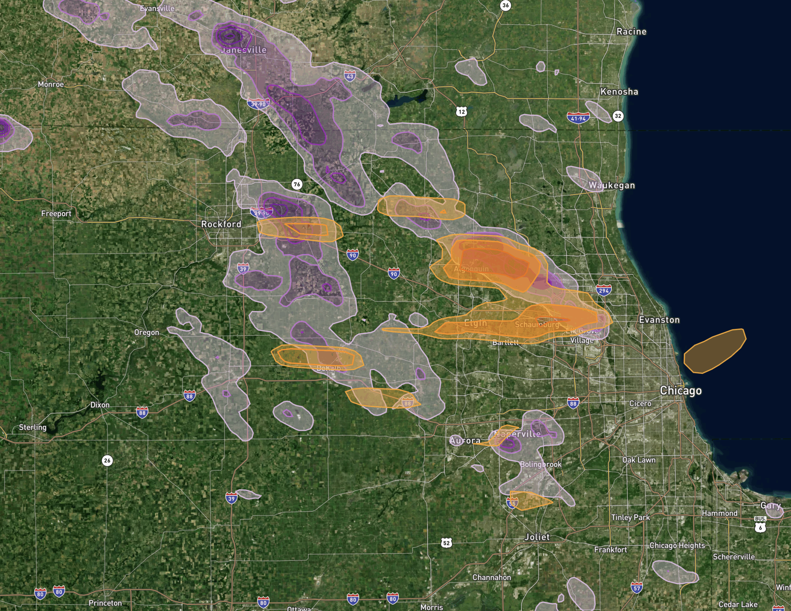
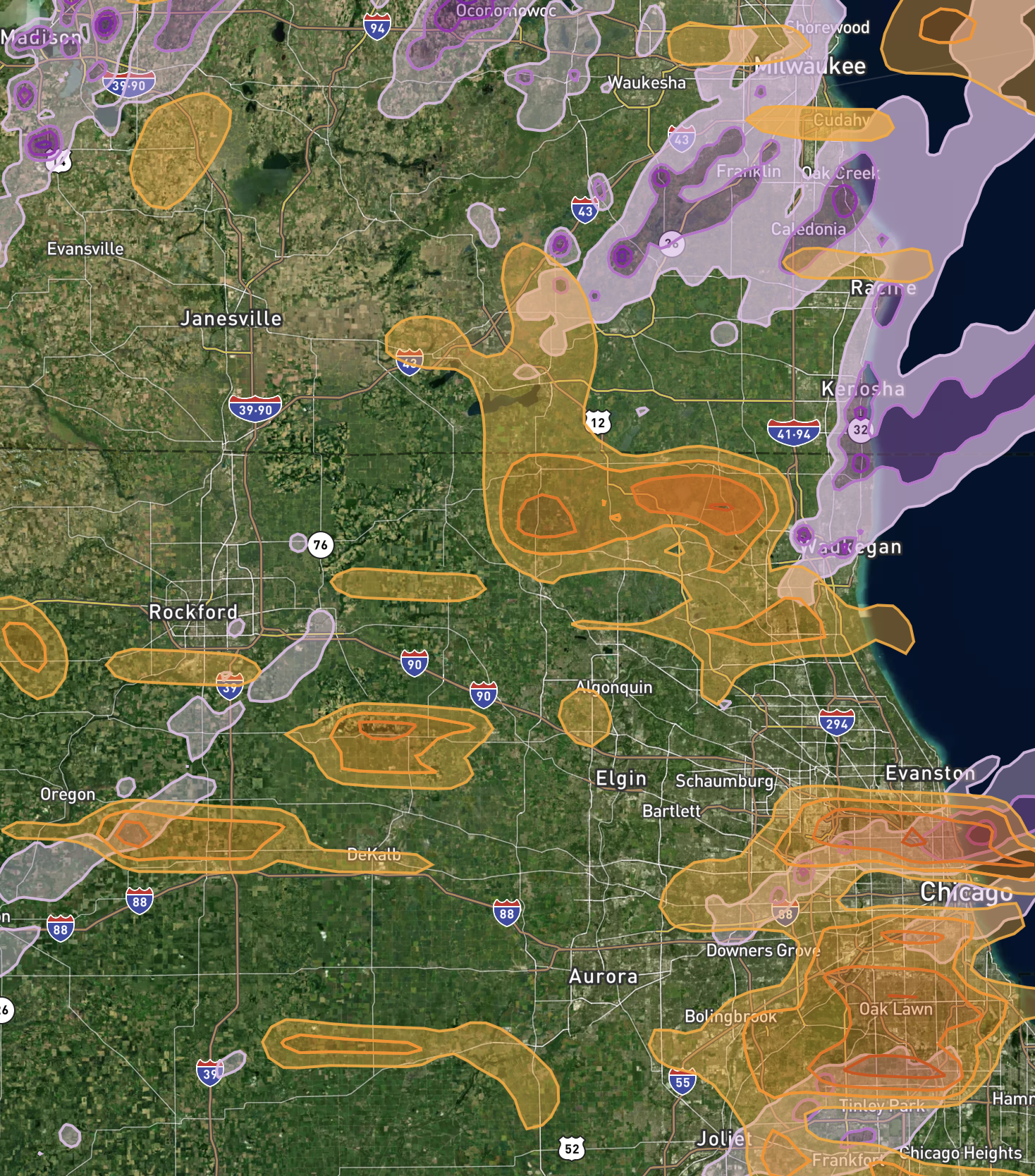
Large Hail Damages Illinois and Surrounding Areas
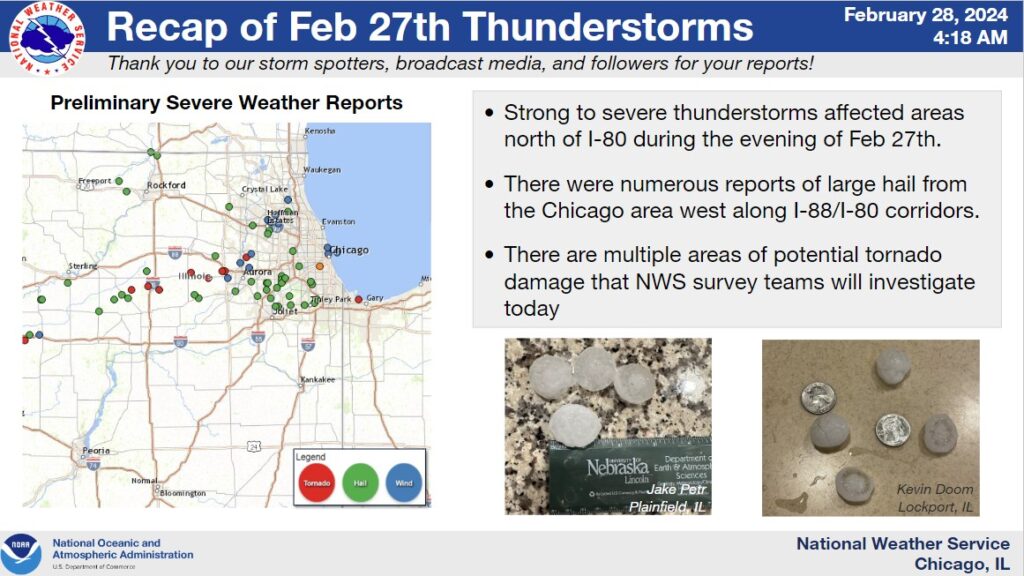
- Ashland, Ashland, OH: 100 – Quarter-sized hail reported through amateur radio.
- Atkinson, Henry, IL: 150 & 175 – Ping pong to golf ball-sized hail, with social media pictures showing the larger sizes.
- Aurora, DuPage, IL: 100 – Quarter-sized hail estimated near Eola and Ogden.
- Battle Creek, Calhoun, MI: 175 – Golf ball-sized hail reported.
- Bolingbrook, Will, IL: 100 & 125 – Quarter to half dollar-sized hail in western and eastern parts of the city.
- Boston, Nelson, KY: 100 – Quarter-sized hail reported via mPING.
- Brownlee Park, Calhoun, MI: 250 & 175 – Hail up to 2.4 inches in diameter measured.
- Colona, Henry, IL: 100 – Quarter-sized hail, with social media pictures relayed by media.
- Decatur, Van Buren, MI: 100 – Quarter-sized hail with wind gusts to 70 mph.
- Dundee, Cook, IL: 100 – Quarter-sized hail relayed via mPING.
- East Dundee, Cook, IL: 100 – Quarter-sized hail estimated by radar.
- Freelandville, Knox, IN: 100 – Quarter-sized hail relayed via social media.
- Geneseo, Henry, IL: 175, 125, 125 – Golf ball to half dollar-sized hail reported, with time estimated from radar.
- Hoffman Estates, Cook, IL: 100 – Quarter-sized hail estimated by radar.
- Huntley, McHenry, IL: 100 – Public report of quarter-sized hail.
- La Grange Park, Cook, IL: 100 – Quarter-sized hail relayed via mPING.
- Lawrenceburg, Anderson, KY: 100 – Quarter-sized hail reported.
- Leon Corners, Whiteside, IL: 100 – Quarter-sized hail, with delayed reports indicating the event’s verification.
- Lockport, Will, IL: 100 – Quarter-sized hail observed by NWS employee.
- Maple Park, Kane, IL: 100 – Quarter-sized hail relayed via mPING.
- Mattawan, Kalamazoo, MI: 100 – Quarter-sized hail reported via mPING.
- Midlothian, Cook, IL: 150 – Ping pong ball-sized hail estimated by radar.
- Naperville, DuPage, IL: 100 – Quarter-sized hail near 87th Street and Naper Boulevard.
- Nazareth, Nelson, KY: 100 – Quarter-sized hail reported.
- Oak Forest, Cook, IL: 150 – Ping pong ball-sized hail near 155th and Long Avenue.
- Oak Lawn, Cook, IL: 150 – Ping pong ball-sized hail relayed via mPING.
- Orland Hills, Cook, IL: 125 – Half dollar-sized hail near 162nd Street and 88th Avenue.
- Pecatonica, Winnebago, IL: 150 – Ping pong ball-sized hail reported.
- Plainfield, Will, IL: 150 – Hail up to 1.5 inches in diameter reported by NWS employee.
- Radcliff, Hardin, KY: 125 – Half dollar-sized hail reported southeast of the city.
- Reynoldsburg, Franklin, OH: 100 – Quarter-sized hail reported southwest and northeast of the city.
- Rineyville, Hardin, KY: 175 & 125 – Golf ball to half dollar-sized hail reported.
- Romeoville, Will, IL: 175 – Golf ball-sized hail shown in broadcast media photos.
- Springfield, Clark, OH: 200 – Hen egg-sized hail reported west-northwest of Springfield.
- Steward, Lee, IL: 150 – Ping pong ball-sized hail reported.
- Sublette, Lee, IL: 175 – Golf ball-sized hail estimated from a photo.
- Sumner, Lawrence, IL: 100 – Quarter-sized hail near Red Hills State Park.
- Terre Haute, Vigo, IN: 100 – Quarter-sized hail reported through amateur radio.
- Vine Grove, Hardin, KY: 100 – Quarter-sized hail reported via mPING.
- Woodridge, DuPage, IL: 200 – Hen egg-sized hail shown in social media photos between Downers Grove and Darien.
The hail reports alone paint a vivid picture of the storm’s severity, with sizes ranging from a quarter (1 inch) to over 2 inches, indicating the potential for substantial damage to vehicles, homes, and crops.
The wind reports highlight the storm’s power, with gusts reaching up to 82 mph in Illinois, capable of causing extensive damage to structures and power lines, not to mention the risk to personal safety during such events. The variety and intensity of these storms serve as a reminder of nature’s force and the importance of preparedness.
As we move forward, it’s crucial for communities and individuals to stay informed about weather forecasts, understand the risks associated with severe weather, and take proactive steps to protect themselves and their properties.
For inquiries or assistance with storm damage restoration, please contact Allied Emergency Services.
For immediate service or consultation, you may contact us at Allied Emergency Services, INC.
Contact Information:
- Phone: 1-800-792-0212
- Email: Info@AlliedEmergencyServices.com
- Location: Serving Illinois, Wisconsin, and Indiana with a focus on the greater Chicago area.
If you require immediate assistance or have specific questions, our human support is readily available to help you.
Disclaimer: This article is intended for informational purposes only. For professional advice, consult experts in the field.
⚡ Need Storm Damage Help? We Serve 155+ Cities
Allied Emergency Services provides 24/7 emergency restoration across Illinois, Wisconsin, Indiana, and Michigan. Text ESTIMATE to (844) 907-2546 for a free estimate in minutes.
Top service areas: Chicago • Naperville • Aurora • Kankakee • Joliet • Rockford • Schaumburg • Milwaukee • Madison • We’re Hiring!
⚡ Storm or Roof Damage? Get a FREE Estimate
Text ESTIMATE to (844) 907-2546
Or call (800) 792-0212 for 24/7 emergency response
AI-powered • No obligation • Licensed IL & WI
Need tornado damage help?
Allied Emergency Services — Licensed IL & WI Tornado Damage Specialists
For 27 years, Allied has been restoring tornado damage across Illinois and Wisconsin. IICRC-certified, EPA Lead-Safe, IL Licensed Roofing Contractor #104.019029. 24/7 emergency response.
Learn about our Tornado Damage service →Free property assessment within 24 hours · No obligation · Insurance claim support