⚡ Storm or Roof Damage? Get a FREE Estimate
Text ESTIMATE to (844) 907-2546
Or call (800) 792-0212 for 24/7 emergency response
AI-powered • No obligation • Licensed IL & WI
Allied Emergency Services is closely monitoring the recent extreme weather event sweeping across the region. With reports of severe hail, tornado touchdowns, and strong winds, our team is prepared to assist homeowners affected by these natural disasters.
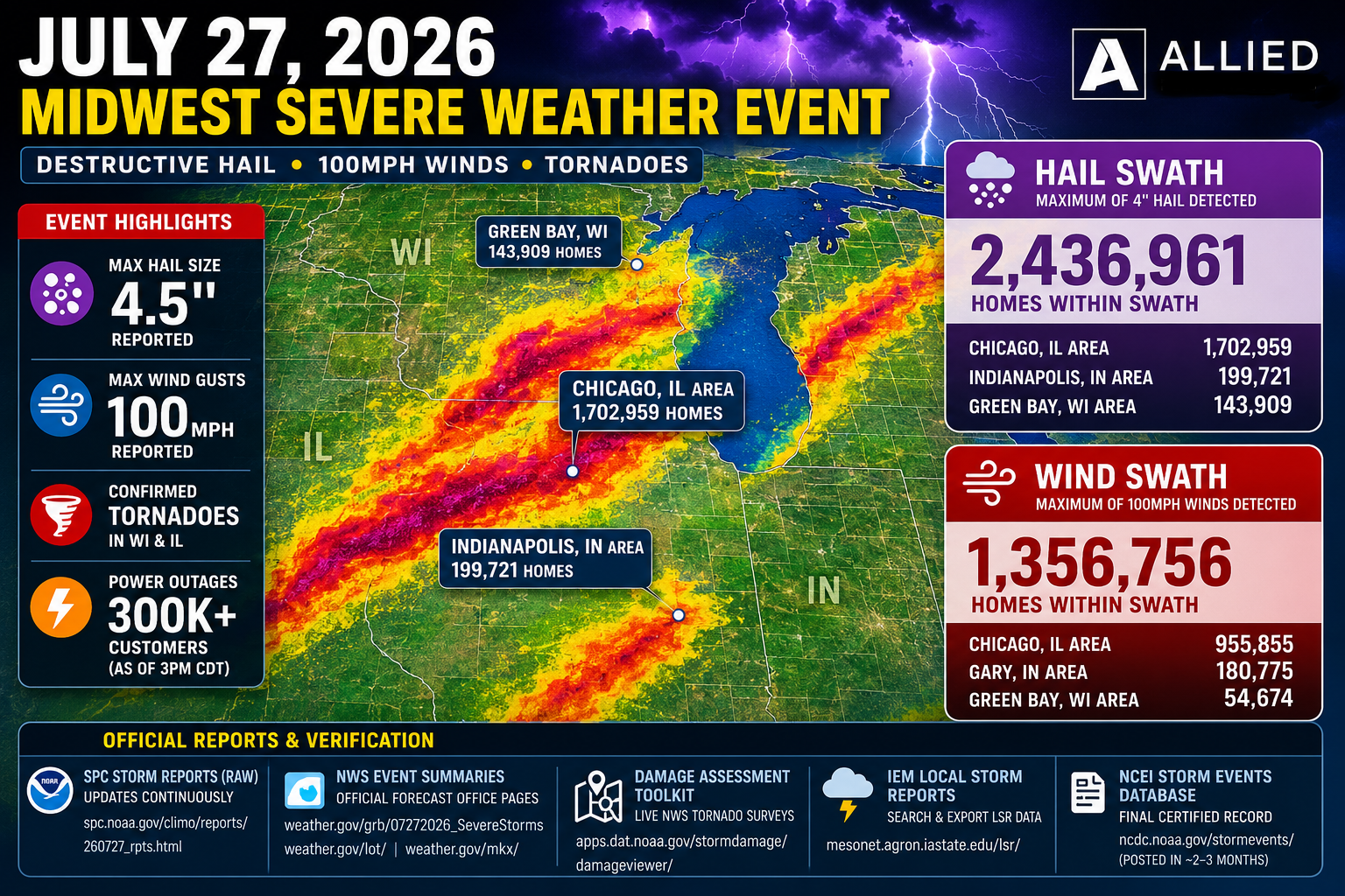
Impact Overview
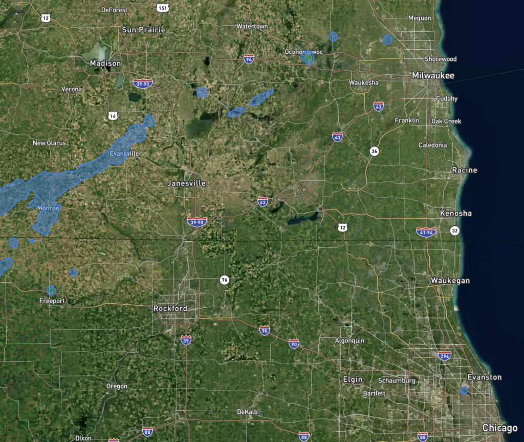
- 18,955 Homes Affected: Within the swath of the storm, a staggering number of homes have been impacted, with the maximum recorded hail size reaching up to 1 inch.
Affected Areas:
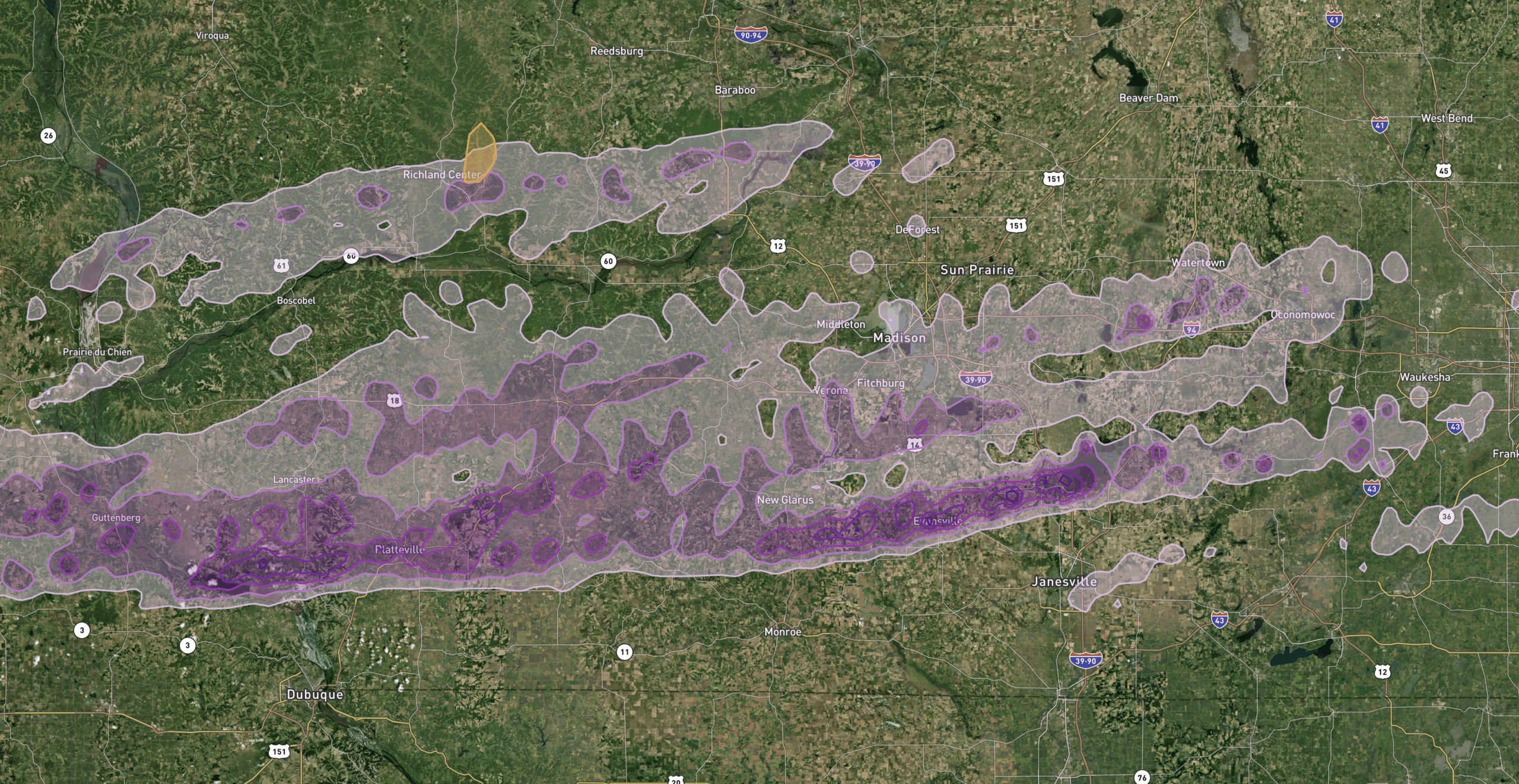
- Madison, WI Area: Approximately 7,236 homes are within the swath, facing potential damage from the storm’s fury.
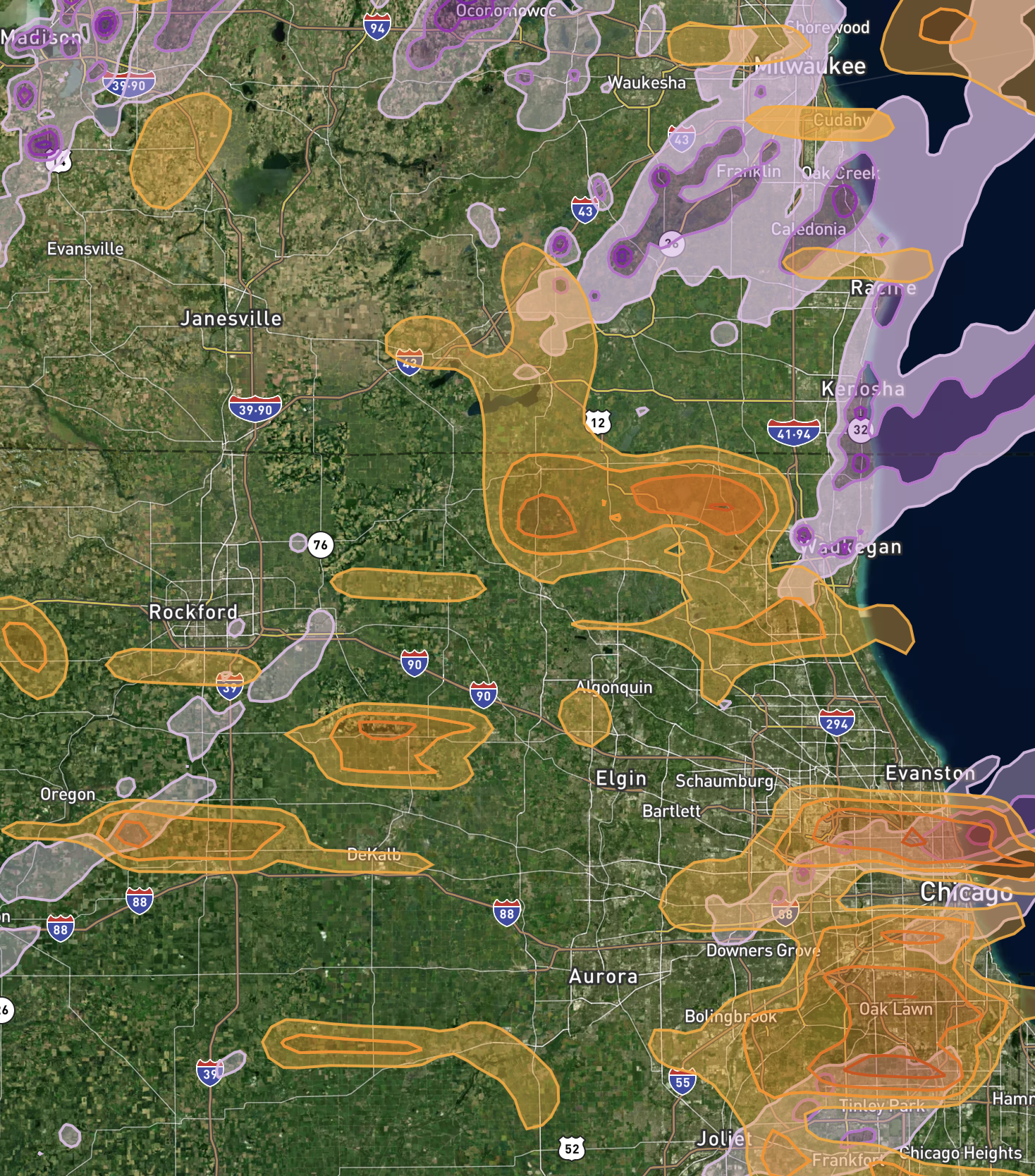
- Milwaukee, WI Area: A total of 3,309 homes are situated in the path of the storm, requiring immediate attention and assistance.
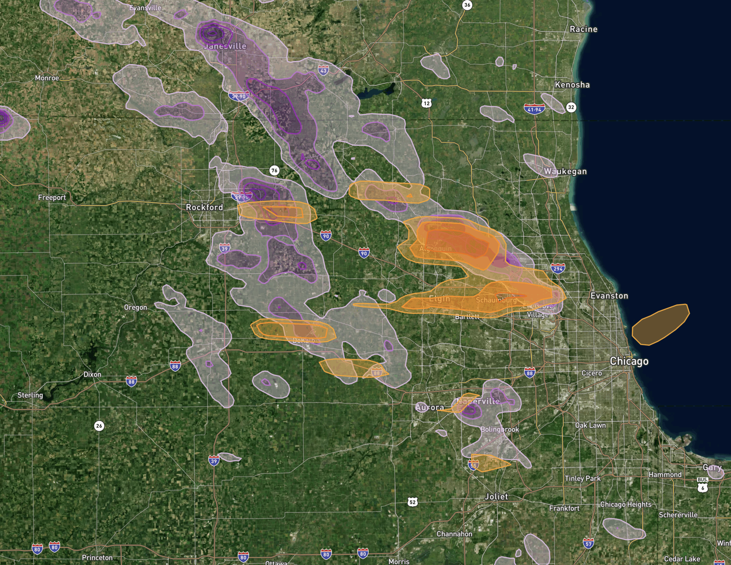
- Chicago, IL Area: With 3,086 homes within the swath, residents in the Chicago metropolitan area are urged to stay vigilant and take necessary precautions.
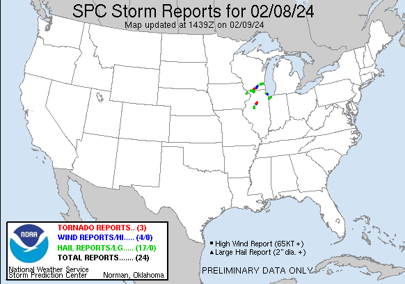
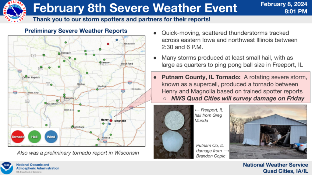
Tornado Reports
- Location: 2 miles South of Henry, Marshall County, IL
- Description: Brief tornado touchdown in an open field.
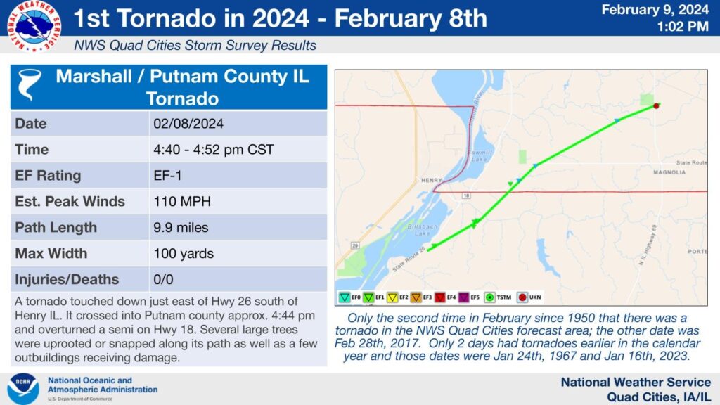
- Location: 5 miles West of Magnolia, Putnam County, IL
- Description: Semi truck overturned with damage to at least one outbuilding and multiple large trees.
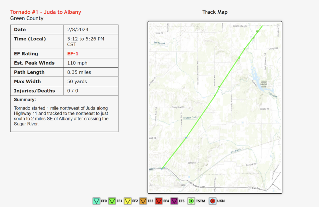
- Location: 2 miles NNW of Albany, Green County, WI
- Description: Reports of tornado on the ground tracking northeast on the north side of Albany.
Hail Reports
- Sizes: Hail sizes ranged from 1 inch to 1.5 inches, causing significant damage to properties in several areas.
- Locations: Notable locations affected include Otter Creek, IA, Norridge, Warren and Winslow, IL, as well as Dakota and Oconomowoc, WI.
- 21:56 (9:56 PM):
- Location: 2 miles West-Northwest of Otter Creek, Jackson County, IA
- Size: 1.25 inches
- Comments: Time estimated from radar. (DVN)
- 22:47 (10:47 PM):
- Location: 1 mile West of Warren, Jo Daviess County, IL
- Size: 1 inch
- Comments: (DVN)
- 22:53 (10:53 PM):
- Location: Winslow, Stephenson County, IL
- Size: 1 inch
- Comments: Time estimated based on radar. (DVN)
- 23:10 (11:10 PM):
- Location: Mapleton, Peoria County, IL
- Size: 1 inch
- Comments: Time estimated from radar. (ILX)
- 23:20 (11:20 PM):
- Location: Bellevue, Peoria County, IL
- Size: 1 inch
- Comments: (ILX)
- 23:26 (11:26 PM):
- Location: 1 mile North of Monroe, Green County, WI
- Size: 1 inch
- Comments: (MKX)
- 23:34 (11:34 PM):
- Location: 2 miles East-Southeast of Scioto Mills, Stephenson County, IL
- Size: 1.5 inches
- Comments: (DVN)
- 23:40 (11:40 PM):
- Location: 1 mile North of Dakota, Stephenson County, IL
- Size: 1.25 inches
- Comments: Delayed report via social media. Hail lasted 5 minutes; started as dime and finished as quarter plus. (DVN)
- 00:09 (12:09 AM):
- Location: 2 miles South-Southeast of Lake Ripley, Jefferson County, WI
- Size: 1 inch
- Comments: Delayed report via social media. (MKX)
- 00:49 (12:49 AM):
- Location: 1 mile Southeast of Oconomowoc, Waukesha County, WI
- Size: 1 inch
- Comments: Delayed report. (MKX)
- 00:50 (12:50 AM):
- Location: 1 mile Southeast of Oconomowoc, Waukesha County, WI
- Size: 1.5 inches
- Comments: Delayed report via social media. (MKX)
- 00:56 (12:56 AM):
- Location: Oconomowoc, Waukesha County, WI
- Size: 1 inch
- Comments: Report from mPING. Delayed report. (MKX)
- 01:12 (1:12 AM):
- Location: 3 miles North-Northeast of Chenequa, Waukesha County, WI
- Size: 1 inch
- Comments: Relayed via Spotter. Photo of hail next to a quarter. (MKX)
- 01:41 (1:41 AM):
- Location: 1 mile Northeast of Norwood Park in Norridge, Cook County, IL
- Size: 1 inch
- Comments: (LOT)
- 01:55 (1:55 AM):
- Location: Menomonee Falls, Waukesha County, WI
- Size: 1 inch
- Comments: Report via social media. Delayed report. (MKX)
- 02:41 (2:41 AM):
- Location: 1 mile Southeast of Portage, Porter County, IN
- Size: 1 inch
- Comments: (LOT)
- 02:50 (2:50 AM):
- Location: Crown Point, Lake County, IN
- Size: 1 inch
- Comments: (LOT)
Wind Reports
- Marshall County Airport, IL: Wind speeds reached up to 63 mph, resulting in potential damage to structures and trees.
- Evansville, WI: Reports of roof damage and large trees snapped underline the severity of the wind impact in this area.
- Rockdale, WI: A large tree, 1 to 2 feet in diameter, was downed, highlighting the destructive force of the winds.
Allied Emergency Services: Your Trusted Partner in Restoration
At Allied Emergency Services, we understand the challenges and uncertainties that extreme weather events bring. Our experienced team is dedicated to providing swift and comprehensive restoration services to help homeowners recover from storm damage.
If your property has been affected by the recent weather event, don’t hesitate to contact Allied Emergency Services for immediate assistance. Our team is available 24/7 to assess the damage, provide emergency repairs, and guide you through the restoration process.
Stay safe and rest assured that Allied Emergency Services is here to support you in weathering the storm.
For immediate service or consultation, you may contact us at Allied Emergency Services, INC.
Contact Information:
- Phone: 1-800-792-0212
- Email: Info@AlliedEmergencyServices.com
- Location: Serving Illinois, Wisconsin, and Indiana with a focus on the greater Chicago area.
If you require immediate assistance or have specific questions, our human support is readily available to help you.
Disclaimer: This article is intended for informational purposes only. For professional advice, consult experts in the field.
⚡ Need Storm Damage Help? We Serve 155+ Cities
Allied Emergency Services provides 24/7 emergency restoration across Illinois, Wisconsin, Indiana, and Michigan. Text ESTIMATE to (844) 907-2546 for a free estimate in minutes.
Top service areas: Chicago • Naperville • Aurora • Kankakee • Joliet • Rockford • Schaumburg • Milwaukee • Madison • We’re Hiring!
⚡ Storm or Roof Damage? Get a FREE Estimate
Text ESTIMATE to (844) 907-2546
Or call (800) 792-0212 for 24/7 emergency response
AI-powered • No obligation • Licensed IL & WI
Need severe weather damage help?
Allied Emergency Services — Licensed IL & WI Severe Weather Damage Specialists
For 27 years, Allied has been restoring severe weather damage across Illinois and Wisconsin. IICRC-certified, EPA Lead-Safe, IL Licensed Roofing Contractor #104.019029. 24/7 emergency response.
Learn about our Severe Weather Damage service →Free property assessment within 24 hours · No obligation · Insurance claim support